Contact us

The NSC Map

dogmeat

Well-known member
Joined
January 28, 2010
Posts
6,490
Version 2.2.2.0 (click for full resolution)
31ToQvTpwX8cujuqjxSC1U


TWMK3gN.png

bTEzFuu.png

3xFTXs6.png

iQznaKE.png

B3X6EvD.png

NYdpQYV.png

FoPRWWu.png

tSymDgX.png

1SN6CDJ.png


Version 2.1:


Version 2.0:


INFORMATION FOR NEW PLAYERS
After you join the Waiting List, I highly recommend looking for a place for your country. The unoccupied areas implicitly belong to both withdrawn nations, and current WLers. With few exceptions, you can claim any territory you wish. Take into account the geography and descriptions of the geocultural regions above, to find what is most fitting to the concept of your nation. PM me and I'll reserve the area for you. I'm also more than happy to answer any of your questions and give advice.
There is no hard limit on how big or small a nation can be, as long as you're not trying hardcore imperialism.
NSC is farily liberal when it comes to worldbuilding. Current nations range from medieval fantasy, to realistic, to futuristic.
 
Last edited:

berlyda

NSC Mod
Staff member
Joined
September 28, 2009
Posts
4,746
Location
Halito
y1lXozH.png


At least it's just history. 1600s were wild xheat

Be careful where you draw that circle for Niponiisle :p The southern half of the archipelago between Halito and Yaponesia consists of man-made islands that did not even exist in the 1600s ;)
 

theditz83

Veteran
Joined
February 7, 2010
Posts
20,645
Location
Scotland & Moisantia
Be careful where you draw that circle for Niponiisle :p The southern half of the archipelago between Halito and Yaponesia consists of man-made islands that did not even exist in the 1600s ;)
My brain found in the gutter - I've read that post 3 times now and I still see "Be careful where you draw that circle for Nippllles" (yep, with 3 Ls) xcookie
 

dogmeat

Well-known member
Joined
January 28, 2010
Posts
6,490
Heej! A new update is coming soon, and it's gonna be much bigger than usual. Apart from adding new nations, Rumian Cartographic Society is preparing a visual overhaul.

Unlike the current world map, the new one will be full of vibrant colors!

We still like current map style and might use it for other purposes in the future. However, we feel adding more color would not only be a nice visual change, but it would give a clearer indication of various climates and types of terrain that can be found in all corner of Natia.

It's been worked on for quite a while and is now nearly finished. Follow this thread and expect the update in a few days.
 
Last edited:

Mattan

Active member
Joined
March 17, 2013
Posts
623
That is one spectacular map. xheat Makes it quite a bit easier to figure out what natural features you can find where, and obviously looks great on top of that.
 

Leydan

Super Moderator 🌴
Staff member
Joined
March 1, 2013
Posts
18,870
Location
UK
This map ia fantastic, i love it. All the little details like the different types of trees to show what type of forest/climate it is, is wonderful. Great work.
 

theditz83

Veteran
Joined
February 7, 2010
Posts
20,645
Location
Scotland & Moisantia
Bravo - that's a purty map. Nice to see the detail like you mentioned to show clear topography and climate zones.

Will you be adding the borders and nation names to this one as well?
 

esc87fan

Well-known member
Joined
April 21, 2013
Posts
19,793
Location
Canada
There certainly is a lot of forestation in the Akihana and Fuyubara regions of Sakuralia, and I can pinpoint exactly where Hanashima Bay is now
 

Gera11

WorldVision Mod 🌻
Staff member
Joined
October 16, 2011
Posts
23,423
Location
București
Fabulous map xlove

I have just one tiny request for the next update:

thanks x
 

dogmeat

Well-known member
Joined
January 28, 2010
Posts
6,490
Thank you for the kind words!

Will you be adding the borders and nation names to this one as well?
Yes, of course. I'll do it soon.

Speaking of...
@Marlfox @TomCherson You're welcome to request a location for your nations. If there are any descriptions of your nations I'm not aware of (on forum, wiki page, etc) please give me a link.


@Gera11 request noted!

As always, I accept any requests. I followed example of Earth geography when deciding what features are found where, but I'm open to unconventional ideas. If you tell me your tropical island is actually super cold because you drop giant ice cubes into nearby waters every now and then, I'm buying that. I may still refuse in rare cases, or if the request would wreck the aesthetics of the map, but it never hurts to ask.

Also, I try to conform the map to individual nations' lore, but it's sometimes hard to locate all of them. If anything on the map contradicts to what you've written on wiki, in your thread or wherever, it's because I missed it. Please provide a source and I'll update the details asap, no matter how tiny.
 

Edweis

Worldvision Mod ❄️
Staff member
Joined
February 10, 2019
Posts
3,257
Location
chocolatine in savouè
Thank you for the kind words!

As always, I accept any requests. I followed example of Earth geography when deciding what features are found where, but I'm open to unconventional ideas. If you tell me your tropical island is actually super cold because you drop giant ice cubes into nearby waters every now and then, I'm buying that. I may still refuse in rare cases, or if the request would wreck the aesthetics of the map, but it never hurts to ask.

Also, I try to conform the map to individual nations' lore, but it's sometimes hard to locate all of them. If anything on the map contradicts to what you've written on wiki, in your thread or wherever, it's because I missed it. Please provide a source and I'll update the details asap, no matter how tiny.
You deserve them,

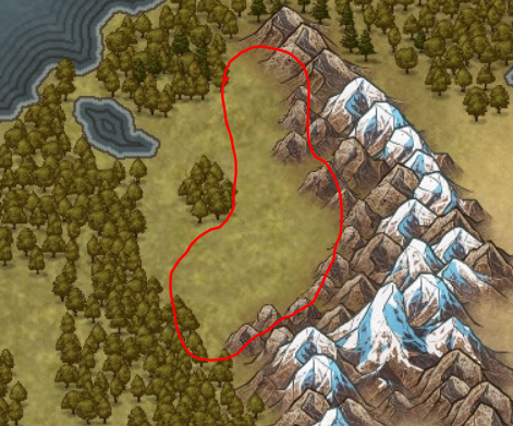
I didn't want to bother at first, but there's maybe one suggestion that I'd like. Can random trees be scattered inside the red lines ? With the denser they become the closer to the mountains they are ?
I didn't put them on my map because I wanted to highlight the very important and dense forests in the middle and borders, so it's not a missing out on your part.
0hjd.png


Thanks a lot in advance !
 

Karhu

Well-known member
Joined
May 9, 2015
Posts
1,225
The new map looks absolutely stunning xheart

I have a few comments on Serenes and its placement on the map that I was meaning to bring up ages ago but never got around to it. I filled out the map inquiry a long time ago, but I remember you mentioning that you had lost access to the responses from that inquiry, and quite frankly I can't even remember half the things I wrote there anyway :lol: But I do know that Serenes has a few defining features, such as:

- a subpolar oceanic climate with 4 distinct seasons but leaning firmly towards the cold side of things
- nearly completely covered in forest (preferably boreal)
- is either an island, or has a coastline with fjord-like features or small islands dotting the coast - or some combination of these

Currently Serenes is located roughly here:

QoCmcMM.png


As you can see this location doesn't really fit the lore I had in mind for the country. The main issue is that it lacks forests, and is also in a bit too warm of an area. It never bothered me and is really no big deal tbh, but with all the recent map developments it feels like a good time to bring it up :p

I had a few ideas of where Serenes might fit better (just suggestions, of course, I trust you with the final say):

LOAtuAS.png
These small islands in the far northeast of Highwind, close to Sundfør
6eKVUZp.png
Somewhere around the eastern coast of Galea, northeast of Rumia, east of Vylkuzeme
uKnfPW9.png
This island in Galea off the western coast of Vylkuzeme

Lore-wise, Serenes is probably a best fit somewhere in Galea, as a region where "time seems to have stopped / home of castles, legends, hardy warriors, and old traditions" - Serenes is a country which rejects modernity and is founded on traditions and folklore that resemble medieval Europe/Scandinavia in many ways, and thus seems like a natural fit somewhere in this region.

Let me know what you think, and thanks for all the work that you've done!
 

dogmeat

Well-known member
Joined
January 28, 2010
Posts
6,490
uKnfPW9.png
This island in Galea off the western coast of Vylkuzeme
This one seems like a good fit. How about the whole peninsula between Vylkuzeme and Rumia (that is everything west of that large fjord)? I wanted to increase average size of nations anyway.
 
Top Bottom